Discover the Benefits of Palm Robotics Solution for
Plantations Monitoring and Early Detection PESTS

One of the most effective methods of ensuring the health of vegetation is the monitoring and early detection of the stresses affecting them. Timely alerts allow growers to implement the treatments that can save their fields and plantations.

20%

Increase in Crop Yields

43%

Protection from Diseases

39%

Lower Production Costs

50%

Reduction in pesticide

50%

Long-Term Savings

How can we Assist you?

Satellite Images and Analysis of Satellite and Weather Data

The utilization of satellite images and their subsequent analysis plays a pivotal role in providing valuable insights across multiple domains, leading to significant advancements in our daily lives. By harnessing satellite imagery, we can predict and anticipate various phenomena, such as weather patterns, environmental changes, and natural disasters, enabling proactive measures and effective planning. By continuously observing the Earth's surface, satellite images allow us to monitor various parameters such as land use, vegetation health, water bodies, and urban development. This monitoring helps in understanding trends, identifying anomalies, and evaluating the impact of human activities on the environment.

Monitoring and Management of Forests, Vegetation, Streams, and Public Parks, Fires and Natural Disasters

Employing satellite imagery, remote sensing technologies, and machine learning algorithms to monitor and manage forests, vegetation, streams, and public parks, as well as detect and respond to fires and natural disasters. This integrated approach enables real-time assessment of environmental conditions, identification of potential risks, efficient resource allocation, and timely interventions for effective conservation, disaster management, and preservation of natural resources.

Environmental Monitoring and Management

The systematic process of observing, assessing, and managing the environment to understand its condition, detect changes, and implement measures for its protection and sustainable use. This involves collecting data on various environmental parameters, such as air and water quality, biodiversity, land use, and climate, to inform decision-making and implement strategies that promote conservation, mitigate pollution, preserve ecosystems, and foster sustainable development.

Early Detection of Agricultural Pests and Diseases

Early Detection of Agricultural Pests and Diseases using Remote Sensing: Utilizing remote sensing technologies, such as satellite imagery and sensors, to detect and identify agricultural pests and diseases at early stages. This enables proactive management strategies, timely interventions, and effective control measures to minimize crop damage and optimize agricultural productivity.

Monitoring and Management of Fruit Trees

Monitoring and Management of Fruit Trees using Satellite and Drone Images and Remote Sensing with AI Technology: Leveraging satellite and drone imagery, along with remote sensing and AI technology, to monitor and manage fruit trees. This advanced approach enables the detection of tree health, growth patterns, pest infestations, and disease outbreaks. Employing AI algorithms facilitates accurate and timely interventions for efficient resource allocation, improved crop management, and increased fruit production.

Early Detection of Red Palm Weevil

Early Detection of Red Palm Weevil (RPW) using Satellite and Drone Images. Utilizing satellite and drone imagery for our unique solution of detecting Red Palm Weevil, a destructive pest that infests palm trees. This innovative approach enables the timely identification of affected trees, allowing for proactive measures such as targeted treatments and rapid response strategies to prevent the spread of the pest and minimize damage to palm tree populations.

If you are involved in one of the following areas, we can help you optimize your work

Agriculture

Forest management

Cities Development

Emergency economy

Research and science

Geology

Archaeology

The 3 steps for monitoring the plantation
and detecting diseases in the trees at an early stage

Collects, processes and analyzes multispectral and thermal data from drone and satellite imagery
Tracks and monitors physiological changes in date palms using unique algorithms and proprietary expertise and know-how
Provides dashboards, insights, reports, and alerts including infestation, damage assessment, nutritional analysis and yield estimates in the Client Platform

Early detection is essential to prevent infection

THE RED PALM WEEVIL

spacer-1

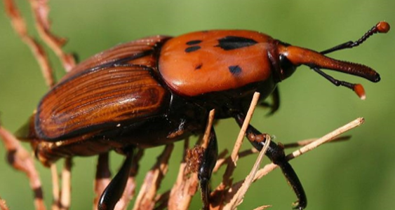
Responding to the urgent need of date palm growers in the Middle East, Palm Robotics present a solution for the infestation of date palm trees by the Red Palm Weevil (Rhynchophorus Ferrugineus). This insect’s larvae burrow deep into the heart of the palm’s vascular system, eating away at the tree from the inside and causing irreversible damage. Tree replacement costs in MENA countries are expected to reach over USD 2.3 Billion by 2023, threatening the livelihoods of small growers in this region and around the world.

red weevil

PALM ROBOTICS SOLUTION

THIS FIRST-OF-ITS-KIND, CLOUD-BASED PLATFORM UTILIZES THESE ADVANCED TECHNOLOGIES

Palm Robotics has developed a unique and comprehensive monitoring system. special algorithms for the early detection of the palm weevil and other diseases based on today's latest technologies.

Over 90% Of Accuracy

Compared to Verification Tools
Results from Plantations in Different Countries in MENA